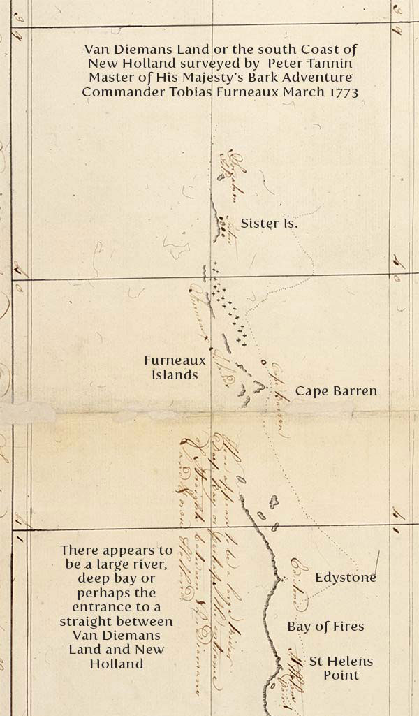
The western sides of Furneaux’s Islands usually present a rocky shore to the prevailing winds and seas, and as far as we know, are tolerably steep to; but their eastern sides are almost universally a sandy beach, and shelve off gradually. There are soundings to a considerable distance from the islands, and perhaps they run across this part of Bass’s Strait. Except some few spots that may be rocky, there seems to be every where a sandy bottom.
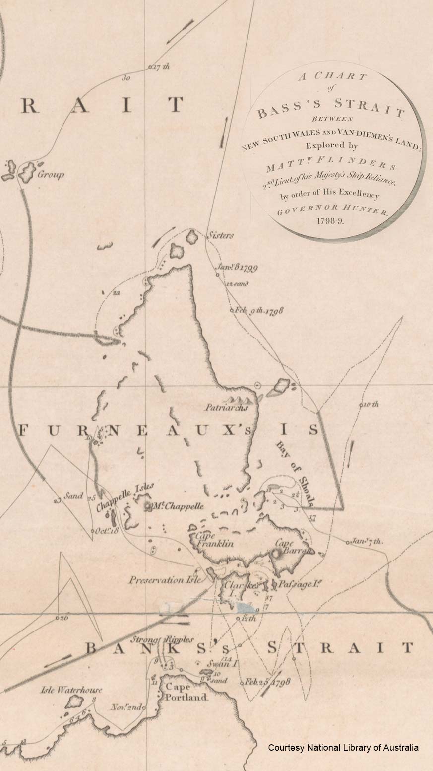
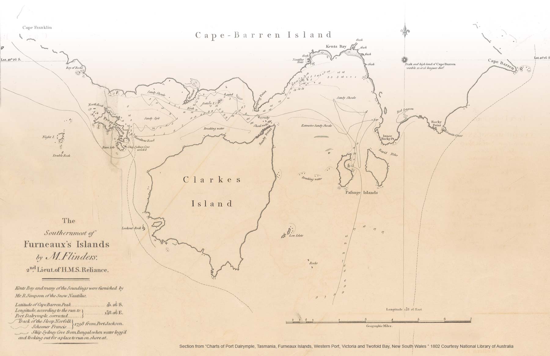
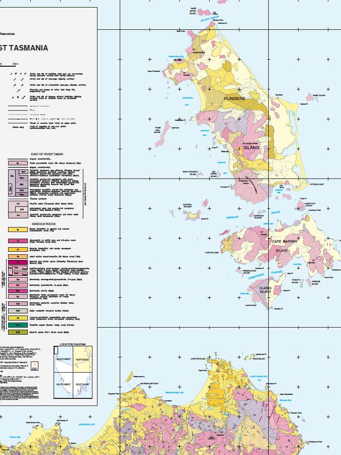
The southernmost of these islands, of which a particular chart is engraved, are by far the best known amongst this large cluster. Preservation Island is one of these, and has its name from having saved the crew of the ship Sidney Cove, in 1797.
She was run aground between this island and Rum Island, and part of the cargo saved. The remains are scattered about the neighbouring shores; and have been seen as far as Wilson’s Promontory and Port Darymple. When coming from the westward to Preservation Island, the island is hid under the higher land of Clarke’s Island.
Lumps of white rock first appear upon it, and upon Night Island. The rocks that lie between these isles must be left on the starboard hand, and the south side of Preservation Island kept as close on board as the state of the wind may make prudent. A reef that lies a short quarter of a mile off Rum Island, will make it necessary not to haul up too close for Hamilton’s Road.
The anchorage is off the sandy beach at the east end of Preservation Island, in from three to five fathoms. This road has hitherto been the place of rendezvous for all vessels that visit these parts, being exceedingly well sheltered against the most prevalent winds; and is tolerably secure against easterly winds, with good ground tackling.
The wind at south, or south-south-east, is the only quarter whence it can do much injury. Not having sounded all the way between Preservation and Cape-Barren Islands, I cannot be certain that Hamilton’s Road is approachable from the northward; but I have no doubt that there is a sufficient channel of eight or more fathoms between these islands.
Cape-Barren Island is, in many parts, high land. The peak, through which the lines of latitude and longitude pass, in the particular chart, may be seen ten leagues; and the mountainous ridge that extends from it almost to the pitch of the cape, is of nearly equal height. A round mountain which stands on the north-western part of this island seems to be still higher than the peak.
There are various places between this island and those south of it, where a vessel might anchor securely when the wind inclined either to the northward or southward of west; but Dent’s Bay seems to be the best anchorage attached to Cape-Barren Island.
To go from Hamilton’s Road towards this bay, no better directions can be given than to keep a good look out for the shoal water, and to compare the chart with the land as you proceed. A vessel may pass very near to Battery Isle, in nine fathoms; and if she has a westerly wind, it will be necessary to haul close around Sloping Point, and keep in with that shore till abreast of the rocks, at the back of which is the anchorage.
My information upon this place is from Mr. Simpson; according to whose survey and surroundings, a ship may be safe here from every wind, and the least depth, at low water, is four fathoms. The Passage Islands are low; and at a distance, will be judged to be but one island.
A little sandy bay in the western island, is well adapted for small vessels to ride in. It is sheltered from all winds, except those between south-south-east and east-south-east. Between the Passage Islands there is a sufficient channel for any ship; and I have no doubt, but that there is a still deeper one between Inner Rocky Point and the eastern island; although nothing larger than a rowing boat has yet passed through it.
Upon one of a small cluster of low islands, subordinate to Furneaux’s Islands, is a mountain, conspicuous for being the only considerable eminence upon them, and remarkable for its uniform roundness. It received the name of Mount Chappelle, in February 1798, and the name is since extended to the isles which lie in its immediate neighbourhood. The passage amongst these isles, through which the track is marked in the the chart, is safe for any ship with a leading wind; being two miles in width, and having more than ten fathoms in it.
The water is very light coloured, both amongst these isles and several miles to the westward of them, the bottom being a white sand. The largest of Furneaux’s Islands seems to be superior in many respects to those that have been mentioned, but our knowledge of it is very confined.
Mr. Bishop, commander of the snow Nautilus, passed through the strait between it and Cape-Barren Island, in a boat; and from him we learn that there are many rocks and isles in it, whose exact situation and form are not ascertained; but it appears, that there is a safe passage through the strait, and some well-sheltered anchoring places in it.
The great body of the large island is high; but neither on the north-western part or on the east side, does the high land come close to the water side. Sandy beaches, almost uninterrupted, skirt these parts of this large island. The west coast is exceedingly high; and overtopped with peaks and knobs of more varied shape and more bare of vegetation, than even the interior mountains to the west of Port Dalrymple.
It was our fortune also, to see the effect of the gleaming sunshine amongst these mountains, after they had been bathed in rain. The spectacle was magnificent. At the moment, we could not blame the sterility that produced so beautiful a scene. The strait that divides this large island from that of Cape-Barren, was hastily examined by Mr. Bishop, commander of the snow Nautilus.
From him we learn, that there are many rocks and isles in it, whose exact situation and form are not ascertained; but that it also contains a navigable passage, and many well-sheltered anchoring places: one of these anchorages is in a bay on the south end of the large island.
The three-peaked hills on the east side of this island, called the Patriarchs, are not unlike each other, when seen to the north-west; but when seem from the northward, they appear as two pyramids; and the island lying off them makes something like the Lion’s Head and Rump, when sailing into Table Bay. The largest of the isles that lie off the west side of the large island, is hummocky, and moderately high: and three principal hills upon it all slope towards the south.
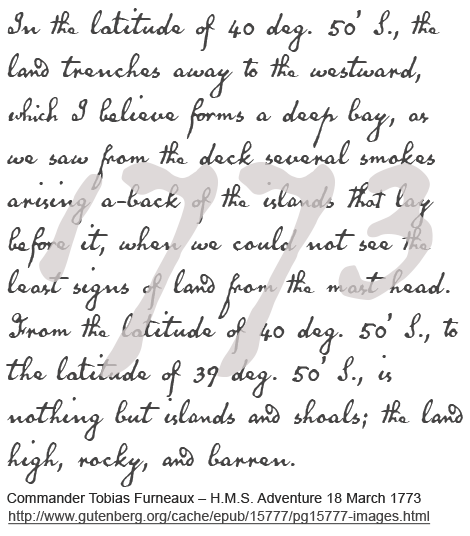
The other patches of land to the north-eastward of these hummocks are low. The Sisters were very well named by Captain Furneaux, being much alike: they may be seen eight or ten leagues. When the Francis scooner was steering to pass between them and the large island, rippling water suddenly made its appearance under the bows. A strong tide might have occasioned this, but lest it should not be so, and to caution others, a reef is marked in the chart.
The tides run strong in the passages amongst the southernmost of these islands. The flood comes from the eastward, between the Passage Islands and the Inner Rocky Point, and continues its course along the south side of Cape-Barren Island. In the deep channel, and particularly off the projecting points, the tide runs with rapidity.
It is high water here, about an hour before the moon comes to the meridian. The rise of the tide appears to be from three to six feet. The tides are represented as running strong, between Cape-Barren and the large island. The lower parts of the southernmost islands are very thickly covered with brush-wood; and in a few places, as in the head of Kent’s Bay, there is small timber amongst it.
The south end of the largest island is said to afford timber of a fair growth; and also a run of fresh water: but the more southern isles are very ill supplied with this last necessary article; the runs into the head of Kent’s Bay yield it more abundantly than elsewhere.
Under the high land of Cape Barren, there are some swamps and lagoons; but the water which drains into them from above, becomes so tinged in its way, as not to be drinkable. Some of these look like ponds of blood. After continued rains, there is a swampy pond of tolerably good water at the east end of Preservation Island; but a small rill that drains from the higher land, on the south side of this island, was thought to have a deleterious quality, from the deaths that happened amongst the Sidney Cove’s crew. Sand, with a mixture of tin and copper, is found on one of the beaches. No inhabitants have ever been seen, or any marks of them, upon any of these islands.
Kanguroos are found upon Preservation, Clarke’s, and Cape-Barren Islands, of the smaller, red kind; and the large grey kanguroos have been seen in considerable numbers upon the southern part of the largest island.
The new animal, called Womat, by the natives at the back of Port Jackson, is found in no inconsiderable numbers upon Cape-Barren Island, and probably inhabits several other of these islands. This animal has the appearance of a little bear. It eats grass and other vegetable substances, and its flesh resembles tough mutton. The animal is about the size of a turnspit dog; but there is not too much meat upon it for three or four people to eat in a day.
A few straggling swans have been seen about Preservation Island, and the lagoons of Cape-Barren Island. In the sandy bay at the south end of the large island, they are represented as being numerous. A kind of brent goose frequents all the islands that have yet been visited.
About the southern islands they are shy, having been frequently disturbed; but on the first visit they usually allow themselves to be knocked down with sticks. These birds are tolerable numerous, and are excellent food. The sooty petterel, called Mount-Pitt bird, is amongst these islands in great numbers. Wherever the tufts of wiry grass are seen, these birds will usually be found.
They burrow in the ground under these tufts, but the length of a man’s arm is sufficient to reach them. The Mount-Pitt birds, can be taken in any numbers during the summer months, at Preservation Island, the Passage Isles, and many other places.
They come in from sea in the evening, in numbers that surprise a person unaccustomed to them. Where Mount-Pitt birds are found, penguins will generally be met with. There holes, however, are not in the same places; the penguin chusing ground to burrow in which is covered with a different vegetation. They are of a small, blue and white kind, and are very indifferent eating. Gannets, shags, gulls, and red-bills, are found amongst these islands; but whilst the swans, geese, and Mount-Pitt birds are in numbers, the former will not be much molested.
Seals inhabit most of the rock points and isles. They are both of the hair and fur kind. Some of the latter are of a good fur, but there seems to be every graduation. The seals were most numerous upon the south-eastern points of Cape-Barren Island, but they are now mostly destroyed. Rock fish are caught at the west end of Preservation Island; but from the various kind of fresh provisions which these islands produce, few attempts were made to catch fish.
The stone, of which the base of Furneaux’s Islands is composed, appears to be of a quartzy nature; and it is only in small pieces that any other kind of stone has been met with.
As far as my particular knowledge of these islands extends, there surface is bare rock, in part; or sand which is covered with brush wood; or swamps, in which small trees grow.
The brush is very often impenetrable; sometimes growing to a considerable height, and sometimes creeping a long the ground: the tall brush-wood is found in the inner and eastern parts of the islands, and the scrub on the western outskirts: a proof of the strength and prevalence of westerly winds. The southern part of Furneaux’s largest island is, it seems, of a different description.
Large timber trees are produced there, and the soil is said to be of sufficient depth and quality to grow corn. In the remarks of my fellow-traveller, Mr. Bass, upon Cape-Barren Island, is the following paragraph: “In point of animated life, nature seems to have acted so oddly with this and the neighbouring islands, that if their rich stores were thoroughly ransacked, I doubt not, but the departments of natural history would be enlarged by more new and valuable specimens, than they ever before acquired from any land of many times their extent.”
http://gutenberg.net.au/ebooks09/0900121.txt


